Indonesia

Kupang, West Timor

“This is Rally Radio, welcome to Indonesia” boomed Dick McCune’s voice over the VHF as we crossed the finish line of the Darwin to Kupang Rally. Continuing in a voice that sounded like an FM radio personality, “come on in to Kupang Teddy’s at the end of the beach, the beers are cold.” This was just the first of many welcomes to Indonesia.

As we were the first to arrive, we had the anchorage to ourselves for awhile, but within a few hours and throughout the night, the fastest boats in the fleet began to quietly arrive and take their places along the beach at Kupang on the west end of Timor Island. The 465 mile passage across the Timor Sea from Darwin was too easy, all downwind, and too much of it motor-sailing when the breeze got too light to keep the spinnaker flying. That evening, we enjoyed a few celebratory drinks, a late dinner on board, and then retreated to our berths looking forward to a quiet and motionless sleep.

That sleep was interrupted well before dawn by some horrible Arabic a capella singing, broadcast loudly with an ample dose of distortion throughout the town. We later learned that the singing, which sounded like Tarzan having his wisdom teeth pulled, was one of the five or so calls to prayer broadcast from the local Mosque starting at 0430 daily. As the morning wore on, the cacophony of vehicle horns, booming car stereos, and loud, distorted music playing outside various shops, mounted a full scale invasion on our eardrums. Welcome to Indonesia!

We were told that Customs, Immigration and Quarantine officials started work promptly at 0800. We were the first boat to be cleared, and they arrived at about 10-ish. This is what is known in Indonesia as “rubber time.” Now normally, when we clear, we are boarded by two to four officials. In this case, we were invaded by ten or twelve people. I couldn’t exactly count them all as they were all over the place. At least there were four of us to keep an eye on them. Customs conducted a very thorough search of every drawer, locker and under and every settee-of the forward half only of the boat. In eleven years, that is the most we’ve ever been searched. Satisfied that we weren’t laden with contraband, they suddenly departed, with the last guy, apparently a hanger-on mate of one of the officials, asking for whiskey and cigarettes. Assuring him we had neither, he shuffled off disappointed to the next boat. Feeling violated, we mentioned this to the rally organizers and they instructed the remaining boats to permit no more than four “officials” aboard. Not exactly an impressive first impression of Indonesian officialdom.

Graham and Todd were eager to check out Kupang so after a quick breakfast, they assembled the dinghy and headed for shore. Merima and I remained behind and gave “Moonshadow” a tidy-up. That afternoon Merima and I headed ashore to stretch our legs and see a bit of Kupang. After a short walk through the town, we felt as if we had seen enough and headed for Teddy’s to see if the beer was in fact cold as advertised.

Over a few bottles of Bintang, the rather tasty local brew, talking with some other yachties who had been before, we learned why we came to Kupang first. They told us from here, it just gets better. What a relief! Kupang made the average Mexican town look pretty flash. The infrastructure, if it could be called that, was literally crumbling under our feet, and there was trash everywhere. Apparently the Indonesians have not embraced waste management. For security, all the shops have roll up garage doors which they pull down when they’re closed for the day. At night and on Sunday, the whole town is a mosaic of various colored steel roll-up doors. We noticed a few of the white trucks with “UN” in blue letters on the side (as seen on TV), reminding us that we were just a hundred or so miles from one of the world’s hot spots, West Timor, which occupies the other half of the island.

As the rally fleet arrived, the crowds at Teddy’s Bar got bigger, and the welcoming festivities began. These consisted of long-winded speeches, in Bahasa Indonesian of course, with broken translation, by all sorts of officials like governors, mayors and regents. This was followed by traditional dancing with loud music, followed by very loud rock music, followed by dinner of mostly unidentifiable food accompanied by deafeningly loud rock music. If the food didn’t drive one away, the music did. Many of us were driven back to our boats anchored hundreds of meters away, where it could be enjoyed at a proper volume. We have learned that every sound device is always played at full volume. Welcome to Indonesia!

Now when one arrives in a foreign country, it’s a good thing to learn a few important phrases like please, thank you, how to order a beer and directions to the toilet, important stuff like that. I asked the Indonesian word for thank you and was told that it was terima kasih. Hell, I asked, how will I remember that? In his own inimitable way, Todd replied “just think tear up my car seat.” Worked for me.

The easiest and cheapest way to get around an Indonesian city is in a bemo. I’m not sure of the literal translation to English, but I would nominate “boom box.” A bemo is a mini van with two long bench seats in back, oriented fore and aft. The ones in Kupang were frivolously decorated with colorful paint jobs, lots of unnecessary lights, bright stickers and various chrome adornments, posters of Bob Marley and/or gorgeous western female divas, and of course, equipped with a copiously loud stereo system. Under each of the bench seats was one solid speaker box with at least a half a dozen sub-woofers, generating hundreds of decibels of sound, mostly the pumping bass track. A defribulator on board would be redundant. The conductor acts as sort of a barker, soliciting customers and collecting the money. He rides hanging mostly out of the perpetually open side door, getting off before the bemo fully stops and hopping on after it is well under way. This leaves the driver to fully concentrate on his driving. This is a good thing, as there are were no traffic signals in Kupang, and driving in Indonesia is a “life in your hands” proposition. The only driving rule is that there are no rules. A ride in a bemo is like walking into a coffin sized disco, complete with large doses of second hand smoke, and deafeningly loud music. The good news is they are very cheap transport. For four of us to go 20 minutes across town to the shopping mall cost a total of 4000 rupiah (the Indonesian currency) or about 40 US cents.

Speaking of the rupiah, if it was the world’s currency, almost everyone on earth would be a millionaire. I changed AUS $400 in Darwin and got over 2.5 million rupiah, which was a massive wad of notes. If you wanted to make a large cash purchase in Indonesia, you would need to show up with a suitcase or wheelbarrow full of notes.

While the grocery store in Kupang was very modern and well-stocked, we realize that we weren’t in Australia anymore Toto, and would need to get used to eating different, non-western foods. This is always one of the interesting and challenging things we enjoy about cruising to new countries. Some of the things we take for granted like mayonnaise, UHT milk, sliced bread, wheat flour and peanut butter are just not to be found here. On the other hand, we did discover some things that we would have least expected to be there, such as A&W Root Beer, 7-UP, Oreo cookies and Tupperware.

Visiting the “locals” market, which is an outdoor arrangement of ramshackle stalls consisting of bamboo poles supporting some sheets of rusty old corrugated iron to keep out the sun and some of the rain, is a completely different experience. This is by far the roughest I’ve seen in 11 years of cruising. The smell of dried fish and decaying vegetables is enough to drive away most westerners. If you can handle that, then the muddy pathways and the foraging rats won’t bother you too much. What we encountered, besides many unrecognizable items, was an assortment of miniature food, covered in flies. Onions were the size of garlic, tomatoes the size of grapes, potatoes the size of walnuts, pineapples the size of potatoes, pumpkins the size of grapefruits, carrots the size of, uh, baby carrots. We’re not sure if they harvest too soon or are just agriculturally challenged. And if the produce was miniature, the prices were miniscule. For example, limes (for caipirhinas) cost us AUS$1.00 each in Queensland, and about the same price per kilo in Indonesia.

Indonesia is an archipelago made up of thousands of islands, so naturally the Indonesians are quite keen seafarers and fisherman. We’ve seen a plethora of boats here, ranging from simple dugout canoes to posh inter-island ferries resembling small cruise ships. What we mostly encounter are either long, narrow open wood canoe-type boats or larger exotic looking trawler boats with a wheelhouse or cabin to protect the occupants from the elements. What they seem to have in common is that they are very low and rakish looking, painted in bright colors and they have incredibly noisy inboard engines. When an Indonesian boat passes, it usually comes close enough to swap paint, and it sounds like either a Harley Davidson motorcycle with no muffler in full throttle acceleration or a Vietnam era Huey helicopter flying over at masthead level. Most of the boats have some sort of primitive inboard engine, as outboard motors are expensive and rare. The Indonesians are quite resourceful and have learned to attach a prop to the end of a Weed Eater, which they then affix one or two to the side of a canoe for propulsion. Of course in most cases they remove the muffler to ensure it reaches proper sound levels. The popping and clacking of any Indonesian boat will immediately cause any conversation in which you may have been engaged to cease, and in some cases fingers to be inserted into ears. In most cases the boats are chock-full of curious Indonesians all waving, smiling and yelling “hello mista” to us. We just smile, pull one finger out of our ear and wave back.

With all these boats running every which way burning up millions of liters of dinosaur juice, it’s a wonder that someone has not embraced the concept of a fuel jetty with electric pumps. Almost everyone uses plastic jugs, filled at a service station, and lugged to the boat. We took on 500 liters in Kupang which was a real welcome back to the third world for me. The local fuel man came alongside with a small canoe and preceded to hand pump fuel from 30 liter jugs into our tank, through our Baja filter of course, to remove all the crap that he insisted wasn’t there. We had to stop twice in the process to clean the filter as it had totally clogged with water and crap. I’m glad I stocked up on Racor fuel filter cartridges in Oz.

With all the rally welcoming ceremonies finished, and the fuel tanks full, we were all too happy to leave the bright lights, noise and smoke of Kupang in our wake and head off to spend a quiet night anchored in the middle of nowhere.

The next port of call on our itinerary was Kalabahi on the island of Alor, about 175 miles north. We were looking forward to Alor as it is purported to have some of the best SCUBA diving in Indonesia. We split the trip into two long day-sails, hugging the north coast of Timor the first day and anchoring for the night in sight of West Timor. We kept a low profile that night, no anchor light and departed for Kalabahi before dawn the next morning. We sailed due north across the Savu Sea and worked our way through the channels leading to Kalabahi.

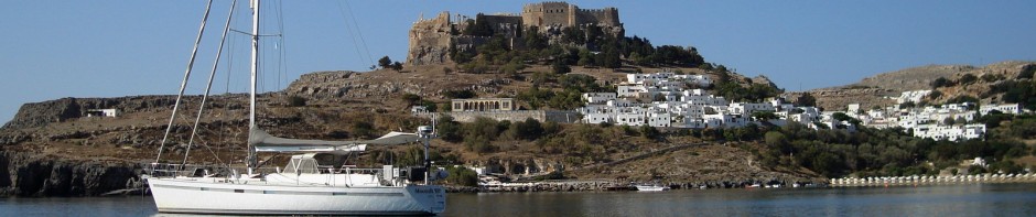
Kalabahi, Alor Island

The numerous small villages clinging to the steep hillsides along the west shore of Alor provided some great scenery as we hugged the shoreline to get some relief from the wicked currents, in some cases more than four knots, in Selat Pantar channel. Finally turning northeast into Teluk (bay of) Kalabahi with a rising tide, we finally got a bit of current behind us and made it to the tight anchorage in time for sundowners.

From a distance in the binoculars, the anchorage looked more like a marina or a raft-up.
We found one remaining spot in the anchorage in reasonably shallow water (less than 20 meters) and carefully anchored, short roding, in a spot that left us quite cozy with four other rally boats. To keep things interesting, the wind Gods made sure to cycle the breeze through at least 360 degrees each day.

Kalabahi was alive with a regional art, craft and music expo, so soon our ears were under full assault from loud music and of course the regular call to prayer from the village mosque. Of course there were plenty of welcoming ceremonies and various other activities for the rally participants, but we came mainly for the diving.

We enjoyed a walk in the village, had a few beers at the temporary “yacht club” set up for the cruisers at the local hotel, and a very nice meal on shore. Of course, some “traditional music and dance” was tossed in for our pleasure.

The next day, we were up early and boarded a traditional boat that had been chartered by DiveAlor, the local outfit to take us to some of the choice local spots. It was a real kick to actually get a ride on one of the boats we had seen going by us many times at close range.

Basic is probably an understatement for this “dive boat.” While it was reasonably clean and in good nik, it was apparent that DiveAlor had a whole kit that they brought on for the dive charter. This included things like dive compressors, tanks, snacks and water that one would expect on a dive boat, but also some things that most Indonesian boats don’t have, like life vests, a first aid kit, carpet for the sun deck (roof), toilet paper, music, those sorts of things.

What amazed me is how these people manage to navigate these boats in the open ocean with such a minimum of gear. The wheel house had just that-a wheel. Nothing else. No compass, no GPS, no VHF radio, no engine instruments, no helming seat, no nothing. Not even a compass. The captain made his way purely by good old fashioned EBN (eyeball navigation). The helm, an old car steering wheel, was connected “Rube Goldberg style” to the rudder post some 40 feet aft by exposed polypropylene lines guided through a series of old wooden pulleys. There was no throttle or gear shifter. Engine control was done by a voice call from the wheelhouse to the “engineer,” a little man stationed below the floorboards in the bilges next to the engine. I have no idea how he could even hear the commands from up front over the racket of the engine. The galley consisted of a single burner diesel stove and an ancient looking tea kettle in a tiny nook across from the toilet. The galley had that “well used” look and oil coating, similar to the engine. The toilet, situated strategically at the very aft end of the boat, was absolutely brilliant in its simplicity. It consisted of a hole in the transom of the boat, with a toilet seat positioned over it, raised off the floor by a round stainless steel chute. There was no flush handle, no bowl, no pipes, no pumps, no holding tank, and other than the hinged toilet seat, no moving parts. Only a yachtie who has suffered through a clogged toilet could really appreciate this. There was a roll of toilet paper hanging on the wall and a bucket of water and a ladle for washing up after. The décor consisted of an assortment of graffiti, either carved or scrawled in felt pen on the three rough-hewn wood bulkheads and door. I guess this was sort of the Indonesian version of “Kilroy was here.”

The most important thing was that we had three excellent dives in the waters surrounding Alor, and shared a great day on and in the water in excellent conditions with some fellow yachties. We encountered loads of clownfish, some black with white stripes, quite a few lionfish, and a couple of interesting frogfish. The soft corals and sponges were prolific, and all in all, the place lived up to its reputation.

Again, longing for some peace and quiet, and with no particular destination in mind, we sailed west the next day leaving the islands of Kuwala and Pantara to our port side. In light airs and calm waters we spent the day watching as seaside villages, massive volcanic mountains with smoking cones and scenic bays and inlets passed us by. We took anchorage off of a sand cay near a pearl farm near the northwest corner of Adunara Island. Enjoying the peace and quiet so much we lingered there for a second day and caught up on some missed sleep and boat chores. Thank God there was no mosque in earshot! Departing early the next morning, we made our way over the northeast tip of Flores Island and took anchorage on a coral shelf just before sunset at a small volcanic cone island called Babi. With a sundowner, we watched the sun drop behind a very picturesque little fishing village situated on a small sand spit extending from the main part of the island.

Maumere (Sea World), Flores Island

Setting sail early the next morning, we arrived near the town of Maumere on the Island of Flores by midday, taking anchorage off just off the beach by a small dive resort called Sea World.

We’d read that Maumere was the largest city on Flores Island, so hopped a bemo into town. We wanted to check the place out a bit, and see if we could score a few provisions and maybe even find an Internet café. Arriving to the center of Maumere, we were completely under whelmed. A large rain squall earlier that day had washed most of the gutter trash into the streets, so the place wasn’t looking too flash. The “central park” was surrounded with barbed wire and a small herd of goats were grazing inside. We weren’t quite sure if the fence was meant to keep the goats in or the people out.

We did find a tidy little Chinese grocery store that had some nice American apples and pears and a few other goodies, but otherwise found Maumere to be only just slightly more appealing than a visit to a Tijuana barrio. On the way back to the boat, the bemo we boarded waited nearly a half hour to fill up with passengers before it made its way out of town. Those who joined us for the ride were mostly young men smoking cigarettes. Between the loud music and smoke, the trip was almost unbearable, and we wished we had walked. For the pleasure of a long wait and an uncomfortable ride, the conductor tried to rip us off for three times the price of the exact same ride in the other direction. Fortunately for him and us, I don’t know any swear words in Bahasa Indonesia.

Back on board “Moonshadow” we washed off the grime and smoke from our Maumere misadventure and then headed back ashore to the resort for sundowners and dinner. The staff of Sea World were most gracious, the facilities excellent, the grounds lovely, and we enjoyed drinks and a delicious buffet dinner for two for about US$14.

At 0630 the following morning we were in a minivan we had hired for the day, on our way to the legendary Kelimutu volcano. For three hours we wound through rainforests, rice paddies, small villages, coconut and banana plantations and steep mountain terrain on a one-and-a-half lane road heading down island to the volcano.

Driving on Indonesian roads requires tremendous skill, intense concentration, rock-steady nerves, split second reactions, and a certification of insanity. From a westerner’s point of view, the roads here make absolutely no sense. Drivers follow way too close, drive in the wrong lane, pass when they shouldn’t, speed frivolously, honk their horns incessantly and stop and park in the middle of the road whenever they feel like it. We came upon a broken down truck blocking one lane of the road, with the driver happily asleep on the ground under the front bumper. Because cars are so expensive, most people drive small motorcycles. It’s not uncommon to see two, three or even a family of four on one Honda 100cc motorcycle. Few have rear view mirrors. The Indonesians driving style would make Evil Kneivel nervous. Some motorcycles have so many boxes and bags attached to their sides that they take up a full traffic lane. The only driving rule seems to be that there are no rules and “might is right,” so if you are in a car, truck or bemo, you can pretty much ignore the motorcycles.

If the chaos of vehicular traffic wasn’t enough, the pedestrian habits thoroughly baffled us. People seem to prefer walking on the roadway to any footpaths alongside. If they want to stop and sit for a rest, they generally prefer to sit on the hot pavement, not in the cool grass or perhaps a log off the side of the road. The farmers love the heat of the roadway and use it freely to process their harvest. On numerous occasions, we saw an entire lane blocked off for at least a hundred meters, using coconut husks as pylons, where copra (coconut), rice or other unidentifiable crops were being dried on those ubiquitous blue tarps. The largest vehicle would assert right of way through the blocked section and the smaller vehicles would just have to keep clear.

On the foot of Kelimutu, we came upon a rice farming village. This area was absolutely stunning, just as depicted on those beautiful Asian paintings, with acres upon acres of small terraced rice paddies, clinging to the mountain’s contour lines. They were flooded with water through an intricate system of viaducts and pipes leading from a mountain stream. All the “soil engineering” appeared to have been painstakingly done by hand. In this instance, the Indonesians have raised agriculture to an art form.

After three hours of what seemed like the scenic version of “Mr. Toad’s Wild Ride,” miraculously, we arrived unscathed at Kelimutu National Park. Now we’ve all seen lots of volcanoes, but a ten minute walk from the car park along a path to the top of the cone revealed why this volcano is totally unique. Kelimutu has three steep walled cones at its lofty summit, each containing a different colored lake. The first cone we came upon resembled a huge cup of rich hot chocolate, complete with white frothy patches. Walking a bit further, a second cone came into view with a lake the color and opacity of the mineral turquoise. Reaching the top, we could see all three lakes, the third one having water that was the color of rich black coffee. The colors of the lakes apparently change over time, as well as with the seasons of the year, but nobody has fully explained the phenomenon. The locals believe that the souls of the dead go to rest in the lakes. The young people’s souls go to the warmth of the turquoise lake, the elder’s to the cool of the brown lake and the souls of thieves and murderers to the black lake. We found it to be a uniquely beautiful sight and well worth the long drive.

That night we enjoyed another meal at Sea World, this time at a table set up for twenty cruisers on the beach. Again the food was excellent, and along with some great conversation, we enjoyed some unique traditional Flores Island music played by a local band at a refreshingly pleasant “unplugged” level.

Riung, Flores

Sailing two full days to the west along the north coast of Flores Island, we came to the small fishing village of Riung. Riung is nestled in a large bay at the foot of a river, and is protected from the seas by a myriad of reefs and beautiful small islands with white-sand beaches. Part of the village extends out over the sea, so the homes are constructed on poles to either side of the main road, which is elevated just above the high tide level.

We found the anchorage in Riung to be excellent, and more importantly, the people were most welcoming and friendly. They even constructed a “princess dock” so that the yachties could land their dinghies, tie up and walk ashore, avoiding muddy beach landings.

While Riung didn’t offer much in the way of shopping or provisioning, we did find some beautiful fruits at the open market, and enjoyed a few nice meals ashore. In particular, we liked a restaurant that was known as “the Pastor’s Place,” which was in a small hotel that looked more like a seminary, situated in the middle of town. “The Pastor” was an elder Polish gentleman who has lived in Riung for 40 years. He puts on an excellent meal in a large room in the hotel that looks more like an austere church’s chapel, and it was evident that he believes cleanliness is next to Godliness. Dinner for two with a couple of cool Bintangs was $US 10. A clean, comfortable, basic room with a western style bathroom is available for about $US 7 a night.

We also enjoyed some good snorkeling on the edges of the reefs, and some walks through the village. Most notable about the primitive looking stilt homes over the water were the electrical meter boxes by the front door and the huge satellite dishes outside. You just can’t fight progress.

Labuan Bajo, Flores Island

After a few enjoyable and relaxing days in Riung, we set sail to the west end of Flores Island to the large port town of Labuan Bajo. We arrived on the 17th of August, which is Indonesian Independence Day. The town was abuzz with ceremonies and parades, so we just quietly made our way through the crowds to the shops and market area of town. While we did find quite a nice assortment of fresh fruits and veggies in the market, and a few goodies in the shops, it is still a bit unnerving to be competing for the goods with numerous large rats and cockroaches. After our shopping expedition, we enjoyed an excellent lunch at very nice little backpacker’s resort situated on a hill overlooking the crowded harbor. There’s nothing quite like relaxing over a meal and a cool Bintang, at a table in a lovely garden of bright bougainvillea flowers, with a view of your boat in the harbor. After lunch we returned to “Moonshadow” and had a leisurely downwind sail to the island of Rinca, which is part of the Komodo National Park.

Crocodile Bay, Rinca Island

Crocodile Bay is a deep, narrow estuary with a cozy anchorage at its end. With the hook down, we caught up with our friends on Calypso, Explorer and Mar Bella who were also anchored there. Crocodile Bay may be a bit of a misnomer, as there no dangerous sub-marine animals present. On the other hand before we could even get our anchor set, we were accosted by two small fishing boats full of young Indonesians trying to sell us pearls and wood carvings of Komodo Dragons. Without invitation they were alongside, tied to our cleats, attempting to get on board. I immediately repelled them, pointing out that an old tire is not a suitable fender and that it was very impolite to invade one’s home in this manner. Loudly and openly displaying my displeasure, I think they realized that due to their overaggressive behavior, we weren’t going to buy anything from them and quietly went off to bother someone else.

We were ashore at 0630 the next morning where we met a guide to take us on a 5 kilometer bush walk in the park. We were greeted at the dock by a Komodo dragon, which is a ginormous (3 meter, 100 kilogram) monitor lizard. While this guy looked pretty relaxed and docile, we were told that a Komodo dragon can swallow an entire goat in one gulp.

At the park station we saw a few more dragons hanging out before we headed off into the bush. We were warned to peek into the toilet before we went inside, as the day before, a dragon had wandered into the men’s and hung out for about an hour. One poor soul, who had to drain his lizard, walked in and had a heck of a fright when he discovered the toilet was already occupied by a much larger lizard.

During our three hour walk, we saw a few more dragons, which appeared to be more healthy and active than the one’s hanging out at the park station. We also spotted a number of small monkeys and a couple of large, wild water buffalo, sporting a massive spread of horns. After our tour, we set sail northwest to a large anchorage on the north side of Komodo Island. From there, our flotilla of four sailed the next day to nearby Banta Island, where we enjoyed a couple of days of excellent diving.

Lombok and the Gili Isles

With nothing much notable to offer the cruiser, we decided to give Sumbawa Island a miss. We left Banta early in the morning and did an overnight, 165 mile sail straight to Lombok Island. Lombok is the westernmost island in the Indonesian regency of E Nusa Tenggara, and the neighboring island to the east of Bali. The conditions during the trip ranged from light and variable, to 25 knots on the aft quarter, with a bit of close reaching in light breezes tossed in to keep things interesting. Crossing the channel between Banta Island and Sumbawa was a real E ticket ride, with strong breezes, ripping currents and over falls. We had the kite up, so were enjoying the ride and hitting speeds up to the mid 12’s.

We enjoyed some nice scenery along the way, with Sumbawa providing some dramatic volcanic landscapes. The most interesting village we passed on the north coast of the island was a shipbuilding community. We could see at least half a dozen large (100-ish foot) wooden ships under construction both on the beach, supported by frail looking bamboo scaffolding and in the water, being commissioned and painted. They were literally the shape of bananas, with bow and stern exaggeratedly high and the amidships section very close to the waterline. The wheelhouses were low and flat, and leaning forward at quite an angle, looking like the rakish roofline of an old hot rod. While these ships typically have (extremely loud) motors, some are also fitted with a small gaff cutter rig and some sort of sails. For its primitive nature, this scene could have been out of a movie about the biblical times and the construction of a fleet of Noah’s Arcs.

Sailing in these waters can be challenging, especially at night. There is plenty of boat traffic, and most of it is poorly lit, incorrectly lit, or not lighted at all. Fortunately and by design, we had a full moon for this leg. During the day, the boat traffic like to pass very close to us and have a look. Unfortunately some of these look-y-loos don’t seem to understand sailing and wind angles, as their curiosity often causes us to either head up to high or down too low in an effort to give them a wide berth. Their comfort zone for passing and mine are obviously quite different. I suppose we’re guests in their waters, so we’ll just try to play their game.

After dark, this becomes a demanding video game. This is how you play: Try to spot the fishing nets strewn across the channel, usually marked with small black flags, if anything. If you do, you won’t have to dive in the middle of the night in shark infested waters to remove the net fouled in your prop. Try to guess the intentions of an unlighted boat that is circling us. Are they pirates who are closing in for a bit of privateering, or just looky-loos with excellent night vision. We keep a wallet full of photocopied cash and expired credit cards handy for the former. Try to figure out why a boat’s nav lights are on one minute and off the next. Lucas electrics perhaps, or pirates? Tired of the game, we finally just turned off all our nav lights and went stealth so that we would be left alone. I’m almost ashamed to report that it worked pretty well. If you do well at the game, you get a few hours sleep and a replay the next day.

We made landfall at Lombok Island the next morning. The anchorage off the north east corner indicated in the cruising guide was so rolly that we back-tracked to some small islets off the coast that seemed to offer better protection. They sufficed as an overnight stop, but there was not much more to offer, so the following day, we continued on to the 
Gili islands, just off the northwest corner of Lombok. We had heard from friends and read from numerous sources that the Gili’s were a cool place to stop and hang out for awhile.

Winding our way through the reefs off-lying Lombok Island, we first called into Gili Air. Anchorage was a bit dodgy in 23 meters of water, and we found ourselves with our back to the shore in a brisk afternoon southeasterly every day. We paid out all 100 meters of chain, and backed down hard on it. We held fast, so decided to chill out there for a few days. Since most of the fleet missed this little gem of an island we had the anchorage pretty much to ourselves.

Gili Air is sort of a cross between Gilligan’s Island and Jimmy Buffet’s Margaritaville. There are a number of small resorts, but all the accommodation units are very simple huts situated close to the beach. The vibe is definitely cool, and aside from diving, chilling out appears to be the main activity for visitors.

There are no motor vehicles on the island. “Transport,” on the island is in the form of pony drawn carts that operate very quietly on a narrow sand road that lies near the perimeter of this small island. The carts are colorfully painted and decorated, and the ponies are dressed in all sorts of adornments, including bells to warn the pedestrians they are coming. If the temperature was about 80 degrees Fahrenheit cooler and the white sand was snow, one might think they were dashing through the snow a one horse open sleigh.

Along this little road are a plethora of bars, restaurants, shops and boutique resort hotels. Rather than typical tables and chairs, most of the bars and restaurants have small pavilions on the beach side of the road. These are little raised platforms resembling a sort of open gazebo, each with a thatched roof, a small table, and an assortment of brightly colored and very comfortable pillows, and room for from two to eight people. Once you have occupied a pavilion, it is becomes very difficult to leave. The friendly wait staff bring you tasty and inexpensive meals, ridiculously cheap and very tasty drinks, and all you have to do is chill out, chat and enjoy the sea breeze and the waves lapping up on the white-sand beach a few meters away. If you are tired of that, you can simply rearrange your pillows, read a good book, take a nap, or contemplate the meaning of life. If you want, you can stay all day, or even all night. If you want some more passive entertainment, there are a number of “cinemas.” A Gili Island cinema is a somewhat larger pavilion with a big screen TV setup at one end, and a pile of DVD’s for you to choose from. If you want a truly relaxing vacation and want to preserve your output of calories as well as dollars, you can’t go past Gili Air.

We enjoyed it so much that we hung out for four days, taking a few nice walks around the two mile circumference of the island, provisioning in the village market, enjoying some great and ridiculously cheap dinners out, and hanging out with friends over $2 caipirhinas at our favorite joint on the beach, the Zip Bar. After chilling a bit, we were ready for a bit of action, so we made the half-hour hop over to Gili Trawangan, a few miles to the west.

If Gili Air is a favorite place to waste away, Gili Trawangan was the place to eat, drink and party. This is where those in the know, who want to avoid all the hustle and bustle, congestion and high prices of Bali, come for a relaxing holiday. The accommodation is casually elegant, the food excellent, and the party scene is enough to keep even the most serious clubbers out till late.

Gili Trawangan is a major destination dive resort with numerous dive shops operating. The difference is that most of them have a pool bar attached. After your dive lesson, you can stay in the pool and have a couple cool ones to rehydrate your parched throat. Or, after your ocean dive, you can hop in the pool, sip on a pina colada and get the salt out of your bikini. Blow bubbles all day, drink bubbles all night without having to even cross the street.

Like Gili Air, Gili Trawangan was slightly anchorage challenged. In this case, it was open roadstead, 20+ meters deep, exposed to wind and some swell, and the currents opposed the wind about half the time. In layman’s language that means it was not exactly comfortable. We enjoyed a day and a night there, and if conditions were a bit more settled, would have stuck around for a bit more fun.

We hadn’t taken on fuel since Kupang, a month earlier, so we were hoping to find some easy and cheap way to take some diesel on board. We worked our way down the east coast of Lombok to the port of Labuhantereng. Once again we found no fuel jetty and wondered how the heck all the big commercial boats in Indonesia take on diesel. We tried to anchor in the soft mud of the shallow bay, three times failed to get the hook set, managed to plow up a few of the ubiquitous black and white Indonesian plastic shopping bags, topped it off by fouling our prop with a fishing rig tied to a very small water bottle. After a half hour under the boat with a mask, snorkel and a razor knife, I had had enough of the place so we headed out to a nearby island resort that had some free moorings.

The Sundancer Resort looks like it will be quite a stunning place when it’s completed. I hope they put some lines on their moorings, as it will certainly make it more attractive to visiting yachties. We spent a quiet night there after a frustrating day, and the following day set sail for Bali.

Posted in All Cruising Logs, Indonesia Logs | Comments Off on Indonesia

Local Knowledge

Nothing can be more daunting than arriving to an unfamiliar country, particularly where language and customs are very different to our own. That said, a bit of homework before landfall can help to ease the stress and enhance the excitement.

I basically divide the informational issues into two main categories; navigational stuff and land-based stuff. Navigational stuff relates to all the boating issues such as clearance ports and formalities procedures, anchorages/marinas, charts, tides and currents, local weather information, fuel and spare parts. Land based issues cover things like language, customs, things to see and do, and necessities like banking, provisioning, Internet and communications.

For navigational issues, we would start the planning process with Jimmy Cornell’s “World Cruising Routes.” I have found this publication invaluable for planning my overall circumnavigation routing, as well as sorting out the legs for each cruising season.

On a more macro scale, we refer to local cruising guides. For every popular cruising ground, there are at least two, if not a handful of good guides available to the cruiser. In addition to the information mentioned above, there are often other bits and pieces of information such as history, local customs, places to eat, things to see and do, walking trails, dive sites, tips on fishing as well as where to get a weather forecast or a cold beer. For Mexico we like John Raines books, for Fiji Michael Calder’s is excellent, the Royal Akarana Yacht Club’s Coastal Cruising Handbook is best for New Zealand and for Australia Alan Lucas’ books and “100 Magic Miles” covering the Whitsunday Islands, all served us well, just to mention a few. For advice on the best for each area, you can usually rely on the nautical chart/bookstore, otherwise ask any yachties who have cruised the area and made it back alive. As a last resort, I would choose any guide written by a delivery skipper or cartographer as opposed to some yachtie’s notes and “mud maps.”

Every good cruising guide will have the disclaimer “not to be used for navigation.” While we do tend to put this information into the navigation equation, one must remember to use these as a supplement to the published charts, good seamanship and one’s own eyes, ears and intuition. My cruising guides, which usually get offloaded to friends who are cruising a season or so behind me, are full of corrections, notes and revisions. After one uses a cruising guide for awhile one can adjust the degree of trust to the degree of accuracy one has experienced.

Once you’ve made it safely to your landfall, are snug in an anchorage or marina, and have dealt with the officialdom, its time to experience a new country. For advice in this area, we rely on word of mouth from friends and yachties who’ve been there and done that, and on the tourist guides. For our tastes in travel, we prefer the “Lonely Planet” guides and nowadays, I won’t buy anything else. “Lonely Planet” guides seem to cover virtually everything else that the cruising guides miss, and if one is going to be in a country for awhile, they even have separate dive guides for most dive destinations, as well as phrase books for non-English-speaking countries. I usually buy up all the books for the next cruising season’s destinations when I fly home, so I have plenty of reading on the plane as well as on passage to where we’re going.

While all the guide books are good, there is no substitute for first-hand experience. A conversation with a yachtie who’s been to where we’re headed, or an ex-pat who lives or has lived there, can provide a wealth of information not found in any book. The questions I most often ask are about security, if they are aware of any problems, if the place is “as charted” or off the charts, about provisioning (what is available and what we need to bring from our departure port) and what are the top five “don’t miss” things to see and do. If you can talk to more than one person, and the stories all agree, then you can rely more heavily on the information. If you get conflicting information, consider the source and error on the side of caution.

Most of the time, the information we have gotten has been pretty good, but every now and then we get burned. The most recent example of this was when we tried to enter the Daintree River on the coast of Queensland, Australia. We went into the Coast Guard office in nearby Port Douglas and spoke to a coastie who told us there was “heaps of water” on the bar, at least 3 meters at low tide. NOT! We were bouncing off the bottom in less than 2 meters at mid tide. The damage was limited to a removal of our anti-fouling off the bottom of the keel. The moral of the story is always be able to gybe away and to have a “plan B” if the information turns out to be bogus.

Posted in All Cruising Logs, FAQ's, Technical Information | Comments Off on Local Knowledge

The Darwin to Kupang Rally

July 23, 2005

Sometimes the most difficult aspect of cruising can be saying farewell to friends we’ve met and places we’ve visited and come to enjoy along the way. This was certainly the case with Darwin.

We had spent just a little over two weeks in the lovely little Tipperary Waters Marina, just outside of town, and really enjoyed some of the locals we met, especially the harbour/lock master Peter Dermoudy. Peter was really fantastic, helping us in so many ways as we arrived into a new town and prepared for the rally to Indonesia. On the evening before we and a dozen other rally participants departed the marina, Peter threw a big barbeque farewell party on the large deck at the top of the marina. We also enjoyed the company of some of the Darwin Sailing Club members like Donna and David, who put so much energy into the rally organization, giving us lifts here and there, providing us with a huge bag of limes for our caipirhinas (they cost a buck each in Oz), and in general helping to make our stay enjoyable. Darwin exceeded our expectation: we were able to get almost everything done on “Moonshadow” that we wanted, we found the local stores excellent for provisioning, and there was even a bit of night life to be had in town.

Darwin has a tidal range of more than eight meters (26 feet), so all the marinas are kept at a constant level of about 7 meters above datum and are accessed through a lock. We locked out of the marina Friday afternoon, full of provisions, with two added crew, good mates Graham and Todd from Auckland, and a favourable weather forecast for the passage. We, and many of the other rally participants spent Friday night on the hook out in Fannie Bay near the start line, enjoying a quiet evening before heading out to sea. The afternoon sea breeze died and the evening was dead calm.

The Australian Bureau of Meteorology had predicted the southeast trade winds would fill in at about 15 knots for the start of the rally at 1100 hours Saturday. They got it wrong again!

We ran the start line on starboard tack and then hardened up for an excellent start under full sail in about four knots of breeze with an outgoing tidal current. We sailed for awhile while most of the rest of the fleet of sixty-odd yachts motor-sailed past us, with engines revved up and diesel fumes billowing. When the breeze dropped off to less than a knot, we furled the headsail, fired up the cast-iron genniker and started heading towards Indonesia with a bit of pace on. Within half an hour, we were enjoying the view of the entire fleet – from over the transom.

With the breeze hovering around the 1-2 knot mark, we were forced to motorsail for nearly five hours till the tradewinds filled in to about ten knots from the southeast. We equaled the engine-on time, flying the spinnaker till just after sunset, when the wind again dropped down to nearly nothing. The engine carried us on through the night on eerily smooth waters.

Just after I started watch at 0500, the breeze suddenly filled in again to about 11 knots. I woke up Merima and we set the kite again and have been enjoying some quiet (if not slow) sailing ever since.

The morning radio schedule showed us to be in front of the fleet, with the next yacht – our friends Pam and Tom on Imagine – behind us by about seven miles, but still in sight and biting our heels.

Just after the morning “sked” the silence was again broken by the sound of the fishing reel going off. We landed a nice wahoo weighing in at about 5 kilos, so we can put the chicken back in the freezer.

As of 1100 hours today, 24 hours into the rally, we’ve covered 181 nautical miles, and the computer says we have 288 nautical miles to go to Kupang which should get us there sometime Tuesday morning.

The weather forecast looks good, with more light winds ahead, the seas are relatively calm, and all is well on board.

July 24

Well it seems as if we had just gotten settled into life at sea when we spotted the island of Timor 60 miles ahead on the horizon. Todd called “land ho” just before lunchtime today.

Our second full day at sea has been pretty uneventful. The fluky winds have teased us into hoisting the spinnaker a few times, only to fade away, causing us to kick over the engine once again. We’ve spent 80% of the last day motorsailing. It’s not all bad, because the seas have been calm, making life aboard very comfortable and easy, and with a 60% power setting, we’ve been able to average 9 knots of speed over the bottom. Between sailing and motorsailing, we’ve covered 207 miles of the course in 24 hours. As of 1100 hours, this left us about 80 miles to go to Kupang, which should get us there in time for a late dinner and a few bevvies.

We’ve noticed some subtle changes since we left Darwin. First off, its hot! The temperature has slowly increased along the way, especially when there’s not much breeze. The water has gotten much clearer and there’s even a bit of bio luminescence. We spotted a small pod of dolphins yesterday afternoon, but they were a bit standoffish and didn’t come over to swim near us. There are heaps of flying fish, which we haven’t seen since we sailed across the Coral Sea last year. Last night we sailed by a group of offshore oil rigs in the middle of the Timor Sea. In addition to lights resembling a small city, they had some pretty wicked tiki torches burning.

Merima has assumed the role of snacktician with a vengeance. While the boys have been plying with the spinnaker, driving and trimming, she’s been putting the galley through its paces. On top of some great meals, the between meal snacks of scones, oatmeal chocolate chip cookies, baklava, etc. have prevented any weight loss during the passage.

As of the morning sked, we were out in front of the fleet about 18 nautical miles ahead of the Farr 58 Imagine. The third place boat, Lady Emma from Auckland, was a further 9 miles behind.

If you happen to be in West Timor, come on by the Moonshadow as there will be a bit of a party on board tonight.

July 25

After an excellent day of sailing in good breeze (finally!), we arrived safely in Kupang about 2130 hours last evening. After a few rums, dinner on a relatively motionless table and a nice bottle of wine, we all fell into our berths, exhausted.

As we made landfall earlier in the day, Timor Island’s dramatic landscape provided a welcome change to the low-lying and flat topography of the Northern Territory of Australia. We reached Oisina Point on the southwest tip of the island just after sunset and were challenged by the last leg of the trip, a northeastward run up the Semau Strait. Semau Strait is wide, deep and well charted, so it would normally be a no brainer. But throw in darkness before moonrise, an unfamiliar patch of water, confusing lights on the shoreline and literally hundreds of local fishing boats working the channel, many with poor or non-existent lighting, and it gets a bit interesting. With Todd and Graham spotting from bow and stern, Merima on the chart plotter and radar giving me ranges and bearings of our course and targets, and me making almost constant course adjustments on the autopilot remote, we managed to weave our way through this fishy Indonesian minefield to the finish line at the open anchorage off the city of Kupang.

We were expecting a quaint little village; Kupang is a full-on city. In fact, there are some 2 million Indonesians on the island of Timor. So, we’re back in to bright lights, noisy vehicles, pollution and all those other wonderful things we thought we had left behind. At least it’s warm, and apparently the beer in Indonesia is cheap.

As we anchored, we were welcomed on the radio by Rally Control, a guy on the radio with a distinctively American accent, who invited us ashore for a cold beer. We declined for the moment in favor of a rum and a late dinner.

This morning we awoke refreshed and waited on Indonesian Customs and Immigration for clearance. They apparently start at 0800, but we were the first boat to be cleared, starting at, oh, about 0930-ish. The entourage of ten boisterous officials in two tenders boarded us, some with sharp uniforms, some with tattered remnants, but all with very dirty shoes and feet. I’m glad we hadn’t cleaned the boat yet. While they were very polite and friendly, they couldn’t have been more disorganized and confusing. We filled out the paperwork, and, of course, stamped it with our obligatory “official stamp,” then allowed them to search the boat for contraband. After opening a few drawers and lifting a few seats, they were satisfied that were not part of an Australian drug smuggling ring and shuffled off to check in the next boat. The last of the group, a little man with a scraggly beard and a very old uniform, quietly asked for beer or whiskey. I politely indicated that the boys had consumed it all.

We completed the 470-mile rally course in 58-1/2 hours for an average speed made good of about 8 knots. All in all it was an easy and gentle passage, and it was nice to be the first boat to arrive. The wind gods were not entirely cooperative, so we ended up motor-sailing about two-thirds of the way.

Meanwhile, as we were cleaning up today, the rest of the fleet continue to arrive, and about half of them are now in Kupang. Guess there will be a big party tonight at Teddy’s Bar on the beach. It’s time for us to clean up and be social.

Posted in All Cruising Logs, Australia Logs, Indian Ocean Logs, Racing Logs, Southeast Asia Logs | Comments Off on The Darwin to Kupang Rally

Australia: Cruising “Over the Top”


  George next to a “rather small” ant hill at Port Essington.

After two months of sailing mostly in a northwesterly direction up the Queensland coast, we had reached “the Tip” or Cape York, the northernmost point on the continent of Australia. We gybed onto port, and started heading in a westerly direction, “over the top” of Australian towards Darwin, which would be our last port of call in Australia.

The first and longest leg of the journey over the top was from the North Queensland outpost of Seisia to Gove Harbour in the Northern Territory, about 360 nautical miles west-southwest across the Gulf of Carpenteria. The Australian Bureau of Meteorology had forecast mostly light southeasterlies for the time period. We were hoping to make landfall in the Northern Territory during daylight hours as we were unfamiliar with the area, so planning a minimum average speed of 7 knots and maximum average of 8 knots, we decided to leave at noon, which I reckoned would allow us to make landfall sometime between 6 am and 6 pm.

Departing on schedule at around noon, we were well into the lee of the North Queensland’s Cape York Peninsula, which blocked the southeast trade winds that had given us a nice ride up the east coast. Winds were light and variable, and after being teased by the breeze into a few futile attempts to sail under spinnaker, we surrendered to the iron genniker and motor-sailed all afternoon.

As we crossed the Inskip Banks, which is a large shallow patch where, in some spots, the depths are less than 3 meters, it got a bit lumpy. There was still no wind as the bottom dropped away to 50-odd meters in the Gulf of Carpenteria. As the afternoon wore on, the seas evened out, so we indulged in our daily showers. Since I was cleaned up for the day, I decided to reel in the lure and avoid having to deal with the mess of cleaning a fish.
As the lure drew up close to the stern of the boat, a large silver fish rose and took a whack at the lure. I stopped reeling instantly. It came back for a second go, and this time the hook set. We boarded an 11 kg Spanish mackerel, and after a catch, fillet and release I was covered in fish blood and scales, and had to take another shower.

 
Merima checking out an old bunker at Port Essington.

By six in the evening, the winds had picked up to the forecast 10-knot level, just slightly forward of the beam, so we put the engine to rest and rolled out the genoa. We were sailing along beautifully at 7-8 knots, right on the rhumb line. The first night was uneventful, just as we like it, but the breeze was gradually increasing to the 15-20 knot range. By early the next morning, BOM Australia revised the forecast to 20-25 knot winds from the southeast. This would definitely increase our speed nicely, but bad news was that away from the lee of Cape York, with hundreds of miles of fetch, the seas had gradually built up to 2-3 meters, short and steep, right on the beam. We were rolling from 15-35 degrees, and finding it a bit uncomfortable. Never mind, our pace had picked up significantly, and we were now averaging 10-11 knots on the rhumb line. We now faced the dilemma that with this increased speed we would make landfall smack in the middle of the night unless we slowed down, further decreasing comfort level.

Carefully studying the charts a bit more, we found that we had a few options if the landfall looked too ugly or scary. There were a few islands off the coast on the west side of the Gulf of Carpenteria that would provide a safe, if not comfortable anchorage till daylight.

We spotted the lights of Nhulunbuy, the township near Gove Harbour, at about midnight. I was now kicking myself for not departing Seisia at 0600 instead of noon, as we could have had the anchor down in time for sundowners! As we approached land, everything – radar, chart plotter, visual bearings, depth – all checked out, and the seas began to moderate in the lee of the Gove Peninsula. We wound our way through the channels between mainland and some low-lying islands with no dramas, and off the township of Nhulunbuy we took temporary anchorage for the night. We enjoyed a good sleep in the calm anchorage and then proceeded around to Gove Harbour the next morning in good light. We’d managed to cram a 48-hour passage into about 39 hours.

This was Merima’s first overnight passage, and unfortunately it was about a 4 on a scale of 10 for comfort. While she didn’t turn out any of her usual gourmet meals under way, I felt she had done just fine…and she didn’t jump ship, so I guess she did too.

Once in Gove Harbour, we gave Moonshadow a much-needed bubble bath and ourselves a well-deserved meal out. We were told that the Gove Yacht Club put on the best meal in town, and in retrospect, after surveying all the options, they were probably right. It was our first shore side meal in weeks, which we enjoyed with a few bevvies, and some great Northern Territory warmth and hospitality.

We were running a bit thin on fresh provisions, so the next day we planned to make the 25-kilometer trip into Nhulunbuy to the market. I asked a lady in the Gove Yacht Club what was the best way to get into town, and she said it was to hitch a ride. We skeptically walked out to the road, and I stuck out my thumb. The first passing vehicle stopped and we hopped in. The man who picked us up had just taken his two young daughters out boating for the morning, and they were all on their way back to town. He dropped us off at the door of the grocery store. I thought to myself that if we were in the States, we might have died of thirst or starvation before we had gotten a ride, and if we had gotten a ride, we would have been found in bits and pieces years later in a shallow grave.

After groceries, we found a bottle shop nearby so went in for a few bottles of wine and some “fish killa” booze. Rather than beat the fish we catch over the head with a winch handle, creating a bloody mess, not to mention pissing off the fish, we’ve found that a squirt or two of spirits over each of the gills is much more humane and puts the fish into a relaxing permanent coma in about a minute. I call it “the parting shot.” Given the choice between the booze and a winch handle, I’d choose the booze every time. Anyway, we couldn’t find any cheap spirits in the shop, so we asked the shop keeper what he might have in the budget range, explaining our purpose of fish euthanasia. He disappeared for a few minutes, leaving the shop completely unattended, returning from the tavern next door with an almost-full, unlabeled “clean skin” liter bottle of gin. He offered to sell it to us for ten bucks if we promised not to actually drink it ourselves, as if it were unsuitable for human consumption. After he boxed up our purchase, he tossed in two new trolling lures, gratis. It seems the further you get from the big cities in Australia, the friendlier the people, and you can’t get much further from a big city in Australia than Nhulunbuy in the Northern Territory.

All topped up with food and grog, we enjoyed another meal out at the Gove Yacht Club that evening. Our plan was to continue our trip over the top towards Darwin with a series of day-sails, starting the next morning.

One of the very few attractions along this route, aside from a lot of sparsely populated Aboriginal land, is a fascinating, if not treacherous feature in the Wessel Islands named the Gulgari Rip, more commonly known as the “Hole in the Wall”. Looking for a bit of excitement, we couldn’t miss it, and positioned ourselves for the trip through the hole by sailing north to nearby Cotton Island. From our anchorage there, we were only a few miles away, so we could theoretically time our passage through just after high tide with a slight bit of positive current.

The Hole in the Wall is a narrow passage between Raragala Island and Guluwuru Island in the southern Wessels. As an aside, it’s interesting that each of those names contains four of the same vowels. Anyway, it is about a mile and a half long, almost perfectly straight, just a couple of boat lengths wide, and during mid-tide the currents can reach 10 knots, making a passage through it more like a whitewater rafting adventure on the Colorado River rather than a placid sail on the Arafura Sea. The strategy for safe passage is to enter the Hole at or near slack water when there is little or no current. If you are heading east to west, you’ll have a bit of positive current just after high tide, and if you’re heading west to east, the same applies just after low tide.

We had a nice, if not slow sail from Cotton Island, arriving at the entrance to the Hole in the Wall at about an hour after the high, so I assumed we would start to get a bit of positive current. Sailing through with just a headsail at about 4.5 knots over the water, we were showing 9 to 9.5 knots over the bottom in the middle of the passage. There were no major rips or whirlpools at this stage in the tide cycle, so we glided through the picturesque waterway as if we were on a riverboat with very little helm adjustment, and in a few short minutes, we were spit out the other end. I can only imagine what it would be like to be caught in there at mid-range on a spring tide (greatest tidal range time) with a strong breeze opposing the current. E-ticket!

Between the Hole in the Wall and Port Essington, some 250 nautical miles to the West, there was not much to see in the way of landforms. The geography was mostly low lying bush land, punctuated by controlled fire burning which made for some very smoky skies and large glowing spots on the night horizon, not to mention soot all over the decks. We were told they were burning off “fuel,” or fallen trees and bushes left from the last tropical cyclone. If the land scenery was not much to see, the sailing was generally easy and pleasant. We were able to cover quite a few miles each day, usually under spinnaker with good southeasterly breezes and flat waters till mid-afternoon, and then find a snug and comfortable anchorage in time for a sundowner. Fishing was good as we landed a few more Spanish mackerel and stuffed the freezer. The most remarkable thing was the number of sea turtles we saw on the surface of the sea, basking in the sun.

After footing it every day for a week since departing Gove, we decided to relax for a few days in the beauty and solitude of Port Essington. Once a British outpost in the early to mid 1800’s, today all that remains are a few ruins and a small eco resort. The small town of Victoria situated at the south end of the long, protected bay, was abandoned in favor of Darwin, which is about 100 miles to the southwest as the cockatoo flies.

We spent two nights in a quiet, calm anchorage off the site of the settlement of Victoria. A walk around the ruins gave us no idea what hardships had befallen the original settlers who suffered through the heat, bugs, crocs, malaria and life of depravation thousands of miles by slow and unreliable ship from the mother land. We wandered between the remains of small stone cottages and giant ant hills, caught a glimpse of a wallaby and evidence of pigs and buffalo, and found the graveyard with its crude crypts and rough-hewn headstones.

The next day, July 4th, we celebrated American Independence at a beach bar-b-que at Coral Bay in Port Essington, with a group of cruisers from the States, England, Canada, Germany, South Africa, Australia and New Zealand. The Britons were very good humored about the whole thing – any excuse for a party, they said. We were reminded just where we were as we spotted a small hammerhead shark in the water off the beach and some large saltwater crocs sunning at the other end of the beach.

Other than the passage across the Gulf of Carpenteria, the most challenging stretch of water in the “over the top” journey is from Cape Don to Darwin through the Dundas Strait and the Van Diemen Gulf. This piece of water is notorious for its wicked strong currents, snotty seas and strong winds. We wanted to get the timing just right so we could use the strong currents to our favor and avoid the nasty waves when the wind opposes tide. From Port Essington, we hopped over to Alcaro Bay, just inside of Cape Don, to wait for the right time to tempt the local sea Gods. After much study in the cruising guides, conversation with other cruisers, consultation of the tide and current charts, listening to local weather reports, careful calculation, a nip of rum offered to the sea Gods and a pinch of salt tossed over the shoulder, we reckoned that a 0530 departure the next morning would be the perfect time.

 
  Moonshadow downlocking in Darwin, with Peter Dermoudy, the lockmaster, waving from the control box.

Well, we got it mostly right, as the Dundas Strait turned out to be a non-event. As calculated, we were able to ride some favorable currents much of the way, and luckily, the seas were mostly flat, but that was owing to the fact that there wasn’t much wind, so we ended up motor sailing much of the way to Darwin. We arrived at Stokes Hill Wharf, off Darwin City at 1700, just in time for happy hour.

The Australian Fisheries people in Darwin are working to eradicate a couple of non-indigenous mussels that are apparently a biosecurity hazard. We were able to coax Chris, the local fisheries agent into working a bit of overtime, with the offer of a rum and coke. We were the last boat of the day to be inspected and cleared for the pesky black-striped and Asian green mussels. Before relaxing with a sundowner and explaining to us more than we could ever want to know about mussels, Chris flushed all of Moonshadow’s saltwater pipes with a lovely pink antibiotic treatment, which permitted us to go into the marina the very next morning, but ruined any chances of us harvesting any future shellfish delicacies from our myriad of plumbing.

The tidal range in Darwin is nearly 8 meters or 26 feet, so as a matter of aesthetics and convenience, all of the marinas are kept at an artificially high water level of about 7 meters, and boats must pass through a lock to get in. We booked into the Tipperary Waters Marina for our stay in Darwin so we could give Moonshadow another much-needed bubble bath, do some minor repair and maintenance, and prepare for the rally to Indonesia.

The last locks that I’d navigated were in the Panama Canal, each of which are about 1000 feet long and 250 feet wide, so ingress and egress weren’t too much of an issue for our 62-foot length and 14.5-foot beam. The lock going into Tipperary was not nearly as ample, giving us just a couple of meters of free play in each direction. At first this was a little bit uncomfortable for me, and quite a bit uncomfortable for Merima, who was new to the whole locking thing. The lockmaster, Peter Dermoudy, calmly explained the process to us over the VHF radio as we approached, and carefully guided us as we entered the lock. The next thing we knew, we had gained 4 meters of altitude, had in hand a set of keys to the facilities, and we were in a snug little marina surrounded by beautiful homes. We made two more trips through the lock later that week when we went to and from the fuel wharf, and by then we had it wired like a couple of pros.

It was great to enjoy two weeks of civilization in Darwin after nearly a month in the outback. We had some great meals out, enjoyed a bit of night life, caught some great live music, did a bit of shopping, a load of provisioning, a few repairs, a little maintenance, and enjoyed some of the local hospitality at the Darwin Sailing Club. There were plenty of social activities leading up to the Darwin-to-Kupang rally, so we had the opportunity to meet some of the other participating boats. We found the Darwinians to be very friendly and down to earth, most helpful, and everyone was happy to give us a lift here and there as we checked items off our “To Do” and “To Get” lists.

We put on six months’ worth of supplies and provisions to get us through 5000 nautical miles of the third world, and welcomed aboard our good mates and regular “MooCrew” Graham and Todd from Auckland, who would join us for the rally.

Our busy days and nights in Darwin flew by, and the next thing we knew, we were sailing over the start line on the Darwin-to-Kupang Rally.

Posted in All Cruising Logs, Australia Logs, South Pacific Logs | Comments Off on Australia: Cruising “Over the Top”

Queensland, Australia: The Whitsundays to Cape York


  Merima with cockatoo, Hamilton Island

I realize that I haven’t tapped out a “Sailor’s Log” for quite some time now, about six months to be exact, but for good reason. I’ve enjoyed the Queensland coast of Australia so much that, in my usual fashion, I got caught in the drift and decided to slow down and savor it a bit longer. With visas and cruising permits extended, we could cram a year of cruising into two years.

That said, I didn’t feel I wanted to be in Tropical North Queensland during the southern hemisphere summer or “wet” season. It’s bloody HOT, with daytime temperatures often reaching 35 deg. C or nearly 100 deg. F. If you don’t mind the heat, then maybe the high humidity and voracious mosquitoes will put you off. Take a dip in the nice cool ocean, you are probably thinking. But you don’t want to stick your big toe in the ocean without a full protection suit from November through March because there are numerous species of stinging jellyfish that can inflict seriously painful or even lethal stings (not to mention crocs and sharks). In fact, Australia’s land, sea and air have more critters that can kill or seriously injure you than probably the rest of the world combined (I have a 192-page book on the subject). On the other hand, for a country with such an inhospitable climate and treacherous inhabitants, it is one of the most fascinating and enchanting places I’ve visited, with some of the most hospitable and fun people I’ve ever met. I decided to wimp out, park Moonshadow in a safe marina with a caretaker, and spend a few months doing some air and land travel in more agreeable climates.

In one paragraph, during this time off I managed three trips “home” to New Zealand, two visits to Sydney, and a visit to the United States and Mexico for a fantastic family reunion on a cruise ship, all by air of course. I followed this up with five-week minor refit and haul out to Moonshadow in Mackay. The highlight of all these wanderings was that I met a wonderful Kiwi lady named Merima, who has joined me as permanent crew. Needless to say, life has been full-on, so it’s great to be ship-shape, back cruising again, with great company and on a more relaxed, one-day-at-a-time schedule.

Last season, I made it as far north as the quaint little tropical resort town of Port Douglas, about 35nm north of Cairns, or about the mid point of Australia’s incredible 2000 km/1200 mile long Great Barrier Reef. This before retracing my course south a bit to Hamilton Island in the Whitsunday Islands, where I left Moonshadow in a safe marina for the southern cyclone season.

Our plan this season was to head northwest along the Queensland Coast inside the Great Barrier Reef to Cape York, or “the Tip” as it is known here, which is the northernmost point of Continental Australia, situated approximately eleven degrees south of the Equator. From there, we planned to sail west across the Gulf of Carpenteria to Nhulunbuy, then “over the top” of the Northern Territory to Darwin, where we will join the annual Darwin-to-Kupang rally on our first leg to Indonesia and Southeast Asia.

 
George with spanish mackerel.  

Merima flew over to join me after the refit in Mackay for a five-week holiday, and to check out the cruising lifestyle. A seasoned traveler, fluent in four languages, she’s always had a dream of sailing the world. Well, after five weeks of leisurely cruising through the Whitsundays and up to Cairns, she was hooked. We both flew back to Auckland to attend the 80th birthday celebration of my good sailing mate Bill Miller the first week of June. Merima decided to grab the rest of her gear and join me as permanent “crew.” We landed back in Cairns, provisioned up, and made the short hop 35 nautical miles north to Port Douglas the following day. Here we will pick up thread from where we left off last season.

Port Douglas is a cool little town that has managed to maintain a bit of its laid-back, local flavor. While it is touristy, it doesn’t seem to get the throngs that inundate the towns on the Sunshine and Gold Coasts down in South Queensland. Situated where a crocodile-infested, mangrove-lined river meets the Coral Sea, it is reminiscent of a backwater bayou town in the deep south of the United States. The Court House Hotel, the main watering hole in town, posts a sight coaxing everyone to take it easy and knock off early with their “Friday session,” which means live music and cheap drinks from 4 pm. And of course there is a Saturday evening session and a Sunday afternoon session as well. The main drag, Macrossan Street, is lined with trendy cafes, shops, art galleries, bookstores, a couple of very trendy nightclubs, as well as a couple of old-time hotels (that’s Australian for pub).

Armed with some “local knowledge” from the Port Douglas Volunteer Coast Guard, we headed ten miles north to the Daintree River, which flows through one of the most pristine Rain Forests in the world, also called the Daintree. We were hoping to spend a day or two anchored up the river, taking in the beautiful scenery and wildlife. I should have known the information was questionable when the guy got confused and suggested I leave the green buoy to port when going over the river bar (bouyage is opposite here to the Americas – it’s port or red to port when returning to port). Anyway, over the bar there was way less water than the 3 meters purported by the coastie, and just past the first mark we were bouncing off the bottom in less than two meters of water. I executed a very quick back-and-fill U-turn and made for deeper water. Crikey!!

With the bottom of Moonshadow’s keel and rudder now very clean, we opted for a hastily made plan B, and sailed north/northwest to Lena Reef. It was a beautiful beam reach in 15 to 20 knots of southeast trade winds and we were gliding along at nearly 11 knots at times in the smooth water inside the protection of the Great Barrier Reef. We anchored just off a coral patch of the outer GBR (Great Barrier Reef).

The following morning we enjoyed a surprisingly beautiful dive on the coral reef just off the boat. The vis was easily 50 meters/160 feet and there was much there to please the eyes. The bottom was dotted with giant clams, some at least a meter across, and with beautiful variegated iridescent mantels. Merima lost her breath when she came face to face with a 3 meter/10 foot long tawny nurse shark napping on the bottom, and became a bit nervous when a large white tipped reef shark made a curious close swim-by. I told her not to worry as they are MAN-eaters. Other highlights were a two meter/6 foot long moray eel and numerous clownfish (Nemo?) It was a beautiful spot in the middle of nowhere and there wasn’t another boat in sight.

After the dive, we motored the short 6 miles north to Ribbon Reef #2. The Ribbon Reefs form the outer GBR, extending for about 100 miles, and offer an average of one world-class dive sites per mile. If you’re a diver, it just doesn’t get much better than this. We had a nice dive on a large bommie just a few boat lengths off our port beam. Vis was pretty good and we enjoyed swim-bys from a small gray reef shark and a large Spanish mackerel. Once again, we were the only ones there.

After a couple of nights anchored out on the GBR, we decided to pop into Cooktown, the last town on the east coast of Cape York heading north. It was the Queen’s Birthday holiday, a long weekend, and they had the Discovery Festival on, commemorating the visit by Captain James Cook during his epoch circumnavigation. We wanted to check it out, and top up on fresh fruits and veggies, as we would be in the “liquid outback” of North Queensland for the next few weeks.

Cooktown reminded us of something out of the Wild West. It is virtually the last real township on the west coast of Cape York until you get to the final outpost on Thursday Island, about 350 miles north/northwest. Some of the old buildings still had hitching posts and a number of the streets were unpaved. If the town is on the edge of civilization, some of its inhabitants appeared to be a bit over the edge. There were lots of dodgy characters hanging around, drinking, and eying Merima with questionable intent. I suppose they don’t see too many sheilas up in these parts. A bit uncomfortable with the vibe, we quickly did our shopping and headed straight back to Moonshadow.

The next drama was a charter sailboat full of guests that came into the harbor at low tide and ran hard aground. The skipper dropped his anchor and then came over in his tender to give me grief for “blocking the channel.” Well, I had entered the very compact harbor, dropped my anchor on the leeward edge of the three meter deep unmarked “channel” and drifted back to settle into water that was just two meters deep, leaving us the luxury of 8″ of water under the keel at low tide. Even though his draft was 2.6 meters, he insisted that I was in his way. I wasn’t in the mood to give Captain Wanker a mathematics lesson, so I apologized needlessly but under my breath suggested that, if he was in fact literate, that he might find some interesting reading in the local tide chart.

In defense of Cooktown, they had a very nice fireworks display that evening, fired from a barge in the middle of the harbor, and an excellent jazz band on the waterfront whose music wafted out to us anchored just offshore. Captain Wanker got off the putty at high tide about 8 PM that evening, and we escaped unscathed early the next morning.

With 13-15 knots of breeze from the east/southeast, we had a comfortable close reach to Wonderland Reef, about 32nm northeast of Cooktown. Wonderland Reef is a large circular coral patch rising out of 25 meters/80 feet of blue water just inside Ribbon Reef #9. We put out all 100 meters of chain and managed to hook the anchor solid in the lee of the reef.

Wonderland Reef is a diver’s wonderland of steep walls, caves, cutbacks and overhangs. There were plenty of colorful tropical fish, large reef fish, and a few pelagics who appeared to be window shopping for a meal. The vis was not as good as Lena Reef, but we could still easily see the bottom. It took us an hour to leisurely circumnavigate the reef, and once again, we had it all to ourselves.

We continued northward on the outer GBR towards a world famous (in Australia) dive site called the Cod Hole. Along the way, we hooked a very nice yellow-tailed kingfish, and brought him right up to the transom, but as I tried to lift him on board, he fell away, having just barely been hooked by the skin of his lucky little lip.

At Cod Hole we picked up a mooring just a few meters from the coral, in a very rolly pass through the reef from the Coral Sea. This was no place to spend a pleasant evening, as the rolling might spill our drinks, so we decided to immediately hop into the water to see what this place was famous for, and then make our way to a calm anchorage. Once in the water, we were descended upon by a family of very large potato cod, some well over a meter long. Their mouths were huge, and they looked as if they could easily nip off a human appendage if their normal food supplies ran low. They appeared quite tame, almost curious, and allowed us to get up close and personal to have a look and take some photos. There were a number of other large fish milling about, including a large maori wrasse and a school of silvery trevally. It was a very fun and interesting dive, and we were the only people in the water for miles around.

After a quick dive, we slipped the mooring at Cod Hole and sailed in light airs 14 nm west to Lizard Island, taking anchorage in the very well protected Watson’s Bay. Shortly after we anchored, our old mate Captain Wanker arrived and anchored next to us. In addition to being mathematically and navigationally challenged, it seems he had also missed the lesson on anchorage etiquette. He ran his rather loud diesel engine all night long while burning all of his deck lights. When I awoke at 0600 the next morning all was quiet and he was gone. Good riddance!!

Hankering for a bit of exercise, we took the tender ashore and walked up to Cook’s Lookout, the highest peak on Lizard Island at 300-ish meters or about 1000 feet. This is the lookout point were Captain James Cook, on his famous voyage, came in hopes of spotting a safe passage out of the Great Barrier Reef. He so named the island because of its population of very large lizards, related to Indonesia’s Komodo Dragons. It was a challenging but beautiful walk. The views were spectacular in all directions – mainland Australia to the west and the outer Great Barrier Reef to our east, and we even saw one of the large (about a meter long) lizards along the way.

Well, it’s not all play on board the Moonshadow, and that afternoon it was time to do laundry. We had quite a bundle and as we got stuck into it, the washer broke down. I quickly diagnosed the problem as a broken agitator drive belt. I was feeling quite smug, as I carry a spare in the parts inventory, and after a few minutes was able to put my hands on it. I played “Maytag Repair Man” and half an hour later the replacement belt was installed and our vintage 1985 Twin Tub washing machine was humming along once again. Well, the “new” belt that I purchased and placed in inventory about 9 years ago had become quite brittle. After one cycle, it also broke, so we were back to hand washing. Bugger!

With the laundry finally finished around sunset, we relaxed in the cockpit with a sundowner and were rewarded with a beautiful Australian sunset and the elusive “green flash.” We were enjoying a quiet moment and reflecting on the day when Captain Wanker came whistling into the anchorage again, dropping his hook next to us and, in typical form, running his engine and deck lights all night. I fantasized about stuffing a potato in his exhaust pipe and shooting out his deck lights with a pellet gun.

Departing Lizard Island the next morning, we found light winds, about 9-12 knots, well behind the beam, so we set the asymmetrical spinnaker. In flat seas we were moving along nicely at speeds from 6-9 knots and soon overtook a gaggle of yachts that had departed a half an hour before us. The winds gradually dropped off to the low single digits, so we gave up and motorsailed to the Pipon Islets. We had our first dolphin visit in ages, and at anchor that evening watched the sun set beautifully red over the Australian continent, finally enjoying a bit of peace and quiet.

On our way to Tijou Reef the next morning, we landed our first fish of the season. It was a Spanish mackerel and rather small at 5 kg, but we were happy to finally break the curse and have some fresh seafood for a change. Our catch was quickly and efficiently processed into sashimi, a batch of poisson cru, a dinner of pan-fried mackerel in a soy-bourbon-coriander sauce, with the remains marinated and to be dried into fish jerky.

From Tijou Reef, we had a quick spinnaker run to the remote outpost of Portland Roads. We hooked two fish, but with speeds of 10-12 knots over the water, we lost both of them. Portland Roads turned out to be a rather rolly anchorage in the east-southeasterly winds.

The following day, on the way to Shelburne Bay, we lost one lure and had another torn to shreds by whatever had struck it. We had a lovely day’s sail under spinnaker in light airs and flat seas. Approaching Shelbourne Bay sort of brings to mind what it must be like to make landfall on the Alaskan coastline in winter. There were lots of wooded areas with absolutely white patches on the hills and along the coast. The silica sand beach and dunes were literally so white, that they appeared to be covered in freshly fallen snow. Now I’ve seen a few “white sand” beaches in eleven years of cruising, but this one wins the Clorox award for whiteness.

From Shelburne Bay, we continued north to the Escape River, our last stop before reaching Cape York. The shoreline was a mixture of white sand beaches and deep red bauxite bluffs, quite a stark contrast, even for Australia. Our luck changing, we landed a very nice 10 kg/22 pound Spanish mackerel. Now we would actually have some meat for the freezer! The only bad news about these Spanish mackerels is that they have a very gnarly set of razor-sharp teeth. I had to be extremely cautious when handling them, wearing a pair of thick leather “gauntlet” gloves. And once we got one hooked, all the soft plastic bits of the lure were shredded. Inside the bar, the Escape River is a very lovely and calm anchorage. There is a massive cultured pearl farm operating there, leaving precious little space for boats to anchor. That evening during sundowners we had a nice chat with a few people working there who ventured by after a fishing excursion. They offered us a small snapper, but we politely declined, being flushed with mackerel.

It was Tuesday, and the big day. Setting sail from the Escape River, winds were light, so we motor-sailed in millpond-like seas. We took a shortcut between Albany Island and the Cape York Peninsula through Albany Pass. This narrow bit of seaway was a lovely green oasis, dotted with a few campgrounds, some excellent beaches and nice little island homestead. A few of the grassy patches of land had some massive ant hills, some easily as high as a tall man. A three+ knot tail current pushed us through too quickly, and soon we were rounding “the tip” or Cape York, the northernmost point of the Australian continent. There was a throng of tourists walking out on the tip, seemingly looking for a glimpse of Papua New Guinea, which lies some 80 miles to the north across the Torres Strait. At about noon, we adjusted our course to the west. The landscape became reminiscent of the South Pacific Islands, with palm trees and expansive beaches, and the color of the water changed dramatically from deep blue to a lighter aquamarine. We were now in the Torres Strait. We navigated through a myriad of reefs and islands along the coastline to the anchorage at Point Seisia.

Seisia is the final outpost on Cape York and consists of a jetty for the ferry to Thursday Island, a gas station, a church, a campground and takeaway shop, a grocery store and a few residences. Everything here is covered with a fine coating of deep red, almost oily dust which seems to be able to stick to or penetrate nearly everything but glass. It seems the main activity for the Seisians is fishing off of the jetty. At the end of the work day, there were easily 50 people with feet dangling off the jetty and lines in the water. When they’re not fishing off the jetty, they’re hanging out on the jetty and socializing over a few beers. We were able to get a few provisions at the well-stocked and comfortably air-conditioned grocery store that would carry us till we got to Gove. We’ll never forget Seisia – we can’t seem to get the red dust out of our thongs.

Reflecting back on the last year in Queensland, I would have to say that it has been some of the best cruising I’ve experienced to date. There are just a few rather minor negatives. The ones that stick out for me are:

  • Lots of shallow water and coral reef. One must extremely diligent about navigation, but I found the charts and cruising guides to be reasonably accurate, and there are plenty of nav aids.
  • The heat, humidity and stingers of summer. At least you can cruise the coast in one season, or else leave the boat in a marina and go somewhere else.
  • Poor availability of sailboat gear. While there are numerous small chandleries, getting any special parts was challenging.

The positives, on the other hand, are too numerous to list, but here are a few of the things that I really enjoyed:

  • An abundance of marinas and good anchorages. From Brisbane to Cape York, over 1200 miles of coastline, one can sail it all in daylight hours and be in a marina or snug anchorage every night. We never had to sail more than 80 miles in one day.
  • Good provisioning. There are various cities and towns along the way where you can get nearly everything you need. Prices for most items are reasonable if not inexpensive. Australian wine is excellent!
  • Plenty to do, in out and on the water. From hiking and cycling, swimming and diving, festivals and regattas to wining and dining, or just beach combing, Queensland is a giant playground.
  • Good weather. Winter weather is settled, pleasant and predictable, and there is plenty of weather information easily available to the mariner. The southeast trade winds are fairly reliable and usually from 10-20 knots. We did LOTS of spinnaker sailing.
  • Great people. Australians in general and Queenslanders in particular are friendly, helpful and usually have a quirky sense of humor unique to Australia. We met lots of wonderful people and made many good friends along the way.
  • There’s no language or cultural barriers, and the officialdom in Australia is easy to understand and work with. We’re going to miss this!
Posted in All Cruising Logs, Australia Logs, South Pacific Logs | Comments Off on Queensland, Australia: The Whitsundays to Cape York

Standing Watch

How do you like to set up your watch-standing system? How many hours on and off watch? Do you have a formal setup, or do you just wing it based on who’s tired and who feels like staying up?

Generally we use an informal watch system during daylight hours, just as long as there is one person awake and on deck to keep an eye out for traffic, trim sails and keep the autopilot steering us on course. At night, we run a more formal watch system, usually 2-1/2 to 4 hours, depending on how many we have on board. This generally runs from 8 or 9 pm till 6 am the next morning. This can be flexible if someone is particularly tired or seasick, and someone else feels like carrying on a bit longer. If I have more than four on board, I usually do a “monster watch,” which means that I take no formal watch slot, but do all the radio skeds and navigation, and take on one of the crew’s watches if they are tired and need a break. Over the years, I’ve found that having the same watch hours each night makes it easier for the crew to fall into a sleep routine. I prefer this system to rotating or Swedish watch systems and always use it aboard “Moonshadow.” Besides, it lends itself to the KISS principle (Keep It Simple Stupid!).

Have you ever singlehanded on a long passage, and if so, what did you do about sleep?

I have done the odd overnight passage single handed, and they have usually been around coastal areas with a fair bit of traffic and navigational hazards. The only diligent solutions that I have found are lots of strong black coffee or energy drinks, loud rock music and toothpicks to keep my eyes open, or else setting the kitchen timer for 20 minutes and cat-napping between alarms. When the alarm goes off, I pop up, check the radar, scan the horizon with the night vision scope, check the chart plotter, and then snooze for another 19.25 minutes if all is well.

Has technology (i.e. radar alarm) made you feel less of a need to be
vigilant?

No!! Radar alarm is great, but it has its limitations. There are still sailboats out there that do not have radar reflectors, and thus do not show up on radar. In places like Mexico, there are pangas (small open boats) and commercial fishing boats made of wood, which sometimes show no lights, making them impossible to pick up on radar and difficult to see until you get very close. A boat heeling without a gimbaled radar dome can miss targets to leeward. I actually find the night vision scope to be more valuable than radar for spotting traffic at a distance. With the scope, I can see the glow of a ship’s lights BEFORE they reach the horizon and can provide any sort of a radar target. At the end of the day, there is absolutely no substitute for good sets of eyes and ears and a nose to smell something fishy.

What do you do to while away the time when on watch? Read? Watch DVDs?
Snack? Enjoy the solitude?

I mostly enjoy the solitude, think, daydream, gaze at the night sky and watch for shooting stars. I read voraciously during the day, seldom at night, but do enjoy an occasional snack. There is absolutely nothing like hot popcorn at O-dark-hundred on a cool morning in the middle of the ocean or a few bits of homemade fish jerky.

How do you protect your night vision?

First off, we use the masthead tricolor light whenever we are sailing so our vision over the deck is not affected by the running lights. Our masthead unit has the added benefit of lighting up the windex so we can easily keep an eye on apparent wind angles. Next, we keep all the instrument illumination on the lowest possible settings, and the chart plotting program, MaxSea, on it’s “night” mode. I have installed a rheostat on the binnacle compass light so we can adjust it down low when we are hand steering at night. We use a pen with a lighted tip for making log entries, eliminating the need to turn on the cockpit light. Inside, we have indirect blue neon “love lights” in the salon so we can see enough to move about without having to turn on cabin lights. I find that a head band mounted LED flashlight (headlight) is great for working on deck. There is less reflection and it keeps both hands free to work and hang on for your life.

Which hours standing watch are your favorites, and which are the hardest?

I find that any hours after 12 straight on watch are the hardest. Seriously, I don’t mind any particular watch slot, but when I’m passaging on “Moonshadow,” as skipper, I always pick the last watch where I get to see the sun rise on the new day.

How do you make sure you get enough rest during the off-watch time,
especially if you have kids? (I could use some advice on that one, and I’m not even on a boat!)

At my advanced age, I can operate pretty well on five or six hours sleep per night. If I have at least two crew in addition to myself, I can usually get that if conditions aren’t too crazy. That said, I usually put my head down for an hour or two in the afternoon so that I’m fresh for the sundown social hour.

Posted in All Cruising Logs, FAQ's | Comments Off on Standing Watch

MooCrew Bio’s

Merima Jaferi joined George on Moonshadow in McKay, Australia in April of 2005 and has since sailed her for 12,000 miles or roughly half way around the world.  A native of New Zealand, Merima began sailing on P-Class as a child as part of her school curriculum and spent holidays cruising on friends yachts over the years.  Although she studied foreign languages in University and is fluent in Italian, French and Spanish and knows a bit of Croatian, her career is in television production.  She works during the New Zealand summers for TVNZ. Over the years she has fully embraced the cruising lifestyle and has attained the rank of Admiral aboard Moonshadow.

In addition to being the highest ranking officer on board, she also has the following responsibilities:

Medical Officer-In charge of keeping the crew, healty and happy and maintaining the medical kit.

Snacktician-In charge of all provisioning and meal planning, as well as being head chef.

Vessel aesthetics-Makes sure that the crew keeps the vessel clean and tidy, and decor is up to muster.

Official translator-Interfacing with all foreign officials.

Bosun’s Mate-Looks after the maintenance of sails, awnings and crew apparel.

Going aloft.

George Backhus has been cruising and racing yachts for more than 30 years and has logged more than 75,000 ocean miles, most of it as skipper of Moonshadow, which he purchased in Ft. Lauderdale, Florida in July of 1994. He is a U.S. Coast Guard Licenced Master and has a Commercial Launchmaster ticket in New Zealand.  He is also a US Sailing Association Certified Instructor.

George’s responsibilities on board include:

Naviguesser

Maintenance and repair of all mechanical and electrical systems

Dive master/bottom cleaner

Catching and cleaning fish

Bartender/Sommelier

D.J.

Langkawi, Malaysia 2006

Malacca waterfront, 2007

Posted in MooCrew Bio's | Comments Off on MooCrew Bio’s

Links

www.noonsite.com “The global site for cruising sailors.  Noonsite aims to provide a one-stop web site featuring essential information on all matters of interest to sailors planning an offshore voyage anywhere in the world, whether already under way or still in the preparatory stages.”


www.yachtyakka.co.nz “yachting news from around the world and around the corner”


www.grib.us  free grib (weather) files for any place on the planet, compatible with MaxSea and other navigation programs
www.setsail.com “the serious cruising sailor’s web site” 
www.stewart34.co.nz  the Stewart 34 Owners Association web site


Posted in Links | Comments Off on Links

Cruising Cuisine

Being “foodies,” as the Kiwis call those who enjoy fine dining, this is a subject that is near and dear to our hearts-and stomachs. At sea, the thing we often look forward to nearly as much as landfall in a tropical paradise is the next meal-and it’s gotta be good!

Early on in my sailing career, I tended to over-provision. I think that this was due to a combination of factors like inexperience, excellent food selection and availability in the US and uncertainty about what might be on offer at our next destination. Over the years, as we passage with fewer crew, I’ve learned how to get more meals from less food, and to find out in advance what’s available from the grocery stores over the horizon.

When passaging, I usually carry enough food for twice the estimated passage time. The main meals for the passage are usually pre-planned, pre-cooked, and very yummy. The back-up food would be things that are easy to store and quick to prepare like pasta, red beans and rice, instant soups and the like. When we are coastal cruising or island hopping, we have a better idea of when we will provisions again, so we may only need to shop for a week or so, unless we are heading off to some remote and secluded place where we plan to spend a month or more.

In the States, the choices for provisioning are overwhelming. With options like Price Costco, Sam’s Club, Trader Joes, and huge, well stocked supermarkets everywhere, it’s just too easy. When one gets to parts of Mexico and many other third world countries, provisioning can seem more like and endless scavenger hunt than a quick dash to the local Safeway. Then add to the frustration with a long hike and/or a taxi or bus ride with melting items, a wet dinghy ride out to the boat, and offloading wet bags of food from a pitching dink, sometimes in the rain, and it can be just plain no fun. So, as you can imagine, we try to do as much provisioning as we can when it is convenient, and just fill in with fresh items when it becomes necessary. In any event, I provision the non-perishables a few days before our departure date, and the perishables at the last possible moment before we depart.

For the past few years, I’ve been cruising the South Pacific Islands, New Zealand and Australia. For the most part, there are at least a few reasonably well stocked grocery stores in Fiji, Vanuatu, New Caledonia, the Cook Islands and French Polynesia. If you are going to Tonga or Niue, you will usually find the basics, (bread, eggs, milk and some canned foods) but anything more exotic may require scavenger hunting. While New Zealand and Australia don’t have the immense warehouse clubs like in the States, the regular grocery stores down under are excellent and have nearly everything one could want. I do most of my regular shopping there, and fill in a gourmet item or two from specialty shops such as Italian or Asian, when I run across them.

We’re fortunate to have almost all the space we need for food storage right in the galley. This is owing partly to a large galley, and partly because I’ve been able to maximize the use of galley space by the use of storage baskets in and on top of the lockers, nesting cooking pots and pans with removable handles, and nesting, graduated sized, sealed containers for leftover food storage. In addition, Moonshadow has two very large lockers in the aft head (situated at the aft end of the galley) which are great for storing some of the bulk food and drink overflow, and there’s enough room under the salon settee to cellar a supply of wine for an entire cruising season. That said, we purchase items in packaging that is boats-storage friendly (plastic bags or bottles, Tetra packs), or repack items in storage containers such as Klick-Klacks or Rubbermaid plastic tubs so they fit better on the shelves and are sealed from insects and moisture. I can usually do a visual to see what we’re low on or out of in just a few minutes, but I usually keep a running grocery list going.

Protecting perishable food is a subject big enough for an entire book, and it has been done very well by Janet Bailey in her book “Keeping Food Fresh.” I keep a copy on board on the reference book shelf and refer to it regularly. Since we have ample fridge and freezer space, it’s not too difficult for us, be we do use a few tricks. We buy perishables at the last possible moment, with the latest “use by” dates, or in the case of fresh fruits and veggies, as un-ripe as possible. Many vegetables (like tomatoes and cabbage) keep perfectly well un-refrigerated. Eggs keep well un-refrigerated if you buy them that way, which is how they are commonly sold in most of the third world, as well as Australia and New Zealand. “Green bags” work very well for long term fruit and vegetable storage. We’ve kept lettuce fresh for weeks in them, and some items like oranges, apples and carrots for more than a month. West Marine sells them under the brand name of Evert Fresh Bags. In New Zealand they are called Peak Fresh Bags and sold in many grocery stores in the fresh fruit and veggie section. We use UHT milk in Tetra packs which will keep for nine months without refrigeration and once opened, can last up to a couple of weeks in the fridge. Fruit juices in Tetra packs store easily and keep well for months. We’ve found that it’s a good idea to keep dry goods in sealed containers and place bay leaves in the ones that have grains, flours and rice to prevent invasion by weevils. If you buy flour in the South Pacific islands, weevil infestation is not uncommon, and almost to be expected. If you spot or suspect weevils in y, you can pop the package into the microwave to kill them. They don’t have much taste, you can’t see them in cooked items, and I understand they are good source of protein. :-p

Speaking of bread, a few years ago the ship’s bread machine died and we were planning a month in a remote area, so we went to the local bakery and bought about six loaves worth of unbaked bread dough. We’d heard that you could freeze it in plastic bags and then thaw and bake it when you wanted a fresh loaf. Well, it seems that the bakery used yeast that was on steroids. We popped the plastic bags of dough in the freezer and within an hour later it had risen to the point that it had opened the (quite heavy) freezer door and started spreading through the galley. We had to round it up and pound it down twice before it cooled off enough neutralize the yeast and the dough would freeze without tripling in size.

Generally we will buy the gourmet and/or hard to get items, as well as quality wines in quantity from shops in the more civilized areas, and just fill in with staples and fresh items from the local stores. That said, there are some great shops in the islands, like She’s Apples in Nadi (Fiji) and Hannah’s Café in Port Vila (Vanuatu), and a variety of gourmet food shops in Noumea (New Caledonia), but be warned that island prices for gourmet items are usually in the stratosphere.

Part of the fun of cruising is learning to use the local ingredients, particularly in places like Mexico and the South Pacific Islands. The locals are more than happy to show you how to make a few of the local dishes that you may take a liking to.

When you are cruising in Mexico or the South Pacific, a must to experience is shopping in the colorful “open air” markets, many of which are now covered. There is nothing that can quite match the sensory overload of the Mercado Municipal in Zihuatanejo (Mexico), or the central market in downtown Suva (Fiji). The fresh meat sections are definitely not for those with a weak stomach (not that blue water sailing is either), unless you are keen on checking out the offerings of pigs heads, chicken’s feet and beef tongue, but the fresh fruit, vegetable and seafood sections are simply incredible. In Suva, due to the strong Indian influence, there is an absolute plethora of curry powders available, and one whole floor of the market is dedicated to the seemingly endless varieties of dried kava root, which is ground and infused to make the local grog. My all time favorites were the fresh tamales sold by little old ladies out of big pots in most of the Mexican mercados. I would take a bunch of zip-lock bags and pack three or four in each and fill up my knapsack. They kept well in the freezer, and could easily be re-heated in the rice-steamer for a cheap and easy lunch. The fresh tortillas hot off the assembly line at the local tortillaria are simply divine. I suggest you always buy extra, because not all will make it home!

When we visited remote areas, the locals offered us items ranging from bananas and coconuts, to lobster, fresh water prawns and coconut crabs, either as a gift or to barter for items that they might need. Before you go into a remote area, I recommend you find out what the locals might need, so you have the correct “currency” of items to barter. Generally speaking, items like D cell flashlight batteries, fish hooks, tobacco, matches, t-shirts, ball caps, pens/paper, magazines, etc. are a good start. Sometimes you will find out from other cruisers on the regular cruising nets what items are in short supply in a particular area where you are headed.

I am a big fan of precooking meals before a passage. I would rather spend an entire afternoon in the galley making a week’s worth of dinners in the calm of the marina, than an hour a day in the galley under way, possibly in a rollicking seaway. Since we make most of our passages short-handed these days, we find that it makes life so much easier and we can relax and enjoy the sailing more. I usually try to put four or five re-heatable meals in the freezer before we set sail. I freeze them as flat as possible and then put them in zip-lock bags so they stack well in the freezer. Don’t forget to mark them for identification. If I have invited crew, they are often happy to bring along one or two frozen meals each such as lasagna, spaghetti Bolognese, or some sort of stew.

My best advice with respect to cooking at sea is K.I.S.S. (keep it simple stupid!). Before you toss off the lines, get into the galley, do lots of cooking and thinking. Take time to organize the galley so that the food items and utensils you use most often are within easy reach. Plan your meals in advance. I like to use recipes that can be cooked in one pot or pan and that use no more than eight ingredients. There are a variety of cook books available that follow this theme. I also have a CD-ROM with a program called “10,000 Recipes” that was floating around a few years ago. You can search the program for a recipe by the name of the dish or a particular ingredient and then choose one that best suits your cooking conditions, ingredients and palette. A pressure cooker is great for shortening cooking times, saving galley time and LPG. I find that it’s easier to double a recipe and have leftovers the next day than it is to cook twice. We keep a set of wide and fairly deep plastic bowls for serving meals when you are in a seaway and are eating off the “lap table.” Once you are under way, try to avoid spicy and fatty dishes, at least for the first few days, especially if the seas are rough or if any of the crew are afflicted by mal du mer.

Most of my favorite meals involve fresh fish, when we can catch it. The options are endless, but one of my favorites, after we’ve made sushi or poisson cru and had a fresh fish meal, is to thinly slice the fillets, marinate them for two days in soy sauce and lemon pepper in a sealed container in the fridge, and then dry the strips on foil lined pans in the sun. Fish jerky is a tasty, low fat snack, and will keep for weeks in the fridge, if it lasts that long!

Happy sailing and bon apetit!

Posted in All Cruising Logs, FAQ's | Comments Off on Cruising Cuisine

Keeping in Touch

One of my great pleasures while cruising is staying touch with all my family and friends back home(s) in the States and New Zealand. Improvements in communications technology have made it very easy and cheap to “reach out and touch someone.”

There are a number of communications devices in Moonshadow’s master control center.

First is the ubiquitous cellular phone. I keep two now, one as a backup. This also allows me to keep switched on to my New Zealand number as well as having a local number for the country in which I’m cruising. In my somewhat limited experience, it seems that even many third world countries have good coverage and cruisers no longer have to rely on the “coconut telegraph,” pay phones other 20th century inconveniences. Most recently, I have found that I could get very dependable coverage in Mexico, Fiji, New Caledonia, New Zealand and all up and down the Queensland Coast of Australia. In most countries it is easy to get a prepay SIM card which gives you a local cell phone number and relatively cheap local calling. In Australia, for example, Vodafone offer a prepay “SuperCap” program which offers AUD$500 worth of international direct dial, local calling, and text messaging for AUD$79 per month. In addition to voice communications, in most countries one’s cell phone can be linked to a PC (via cable or infrared) for Internet access on board, albeit a bit slower than a land-line dial-up connection. Vodafone in Australia and New Zealand now offer GPRS service, which is a high speed mobile (a little faster than land-line dial up) Internet connection via cell phone, but being relatively new, I find it is still a bit pricey.

Many of the marinas here in Australia have a service called MarinaNet. This is a wireless LAN (local area network) within the marina environment to provide high speed Internet access to yachties who have mobile wireless technology on their computers. I find this to be an excellent service and at a cost of about AUD$15 per week-way easier, cheaper and safer than going to a café, and without all the hassles of land lines.

For email when I’m at sea or cruising in remote areas, I still use good ‘ol SailMail. I think this is still the best value for money for on-board email, and improving all the time. At last count there were 14 stations worldwide, each with a variety of available transmission frequencies. I can testify that I have NEVER been unable to connect. I’ve upgraded my Pactor modem to the PTC III level, so I can do all the email I want easily within the ten-minute-per-day allotment. One can now even receive small grib (weather) files on SailMail.

As a backup to the above systems, and for the occasional need to log on (collecting weather grib files) or talk from the middle of the ocean, I have an Iridium phone. Although it seldom gets used, it’s a relatively inexpensive form of worldwide communication and it is comfortable to know that I can call anywhere any time from out on the big blue hiway.

I rarely use Internet cafes unless I need to transmit a very large file or do some serious web surfing, but they seem to be everywhere, and more common than McDonalds, at least wherever I’ve been in the last few years. Curses to French keyboards!

As for good ol’ fashion snail mail, there still are a few people who choose to send that to me, mainly creditors. I have mom in the States and a collection point in New Zealand that forward it to me, minus the junk mail. The cost of re-mailing, hassle of finding a forwarding address and down time waiting for it make it a real pain in the transom, but I do look forward to getting my monthly issue of Latitude 38 in my monthly mail packet from the States.

Bills Bills Bills!

There is no question that the Internet has made cruising more user friendly, and nowadays paying bill on line, at least the moving of money anyway, is very easy and efficient.

Virtually all the expenses of cruising today can be paid for by credit card. The only bad news is that my VISA cards frequently end up with a bad case of RSS (repetitive swipe syndrome). I pay by plastic wherever possible and accrue frequent flyer miles for the occasional trip home in the process. My credit cards are set up on automatic payment from my bank account, and I can review the statements on line whenever I wish. I handle most other expenses with cash (ATM’s are everywhere) or by direct deposit/funds transfer. There are a few odd bills that are paid the old fashioned way, with a check, by mom back in the States.

I think we are all concerned about Internet security issues, but I do all my bill paying from my own laptop which has firewalls, spyware and all sorts of other stuff that are meant to protect me. So far, knock on wood. . .

Posted in All Cruising Logs, FAQ's, Technical Information | Comments Off on Keeping in Touch